
Location
Hill: chamundi hills
City: mysuru (mysore)
District: mysuru district
State: karnataka
Pin code: 570010
Coordinates: 12.2725° n, 76.6707° e
Distance from city centre: 13 km east of mysore city
Nearest railway station: mysuru railway station, approx. 6 km
Nearest airport: mysore airport, approx. 15 km
Nearby cities: bengaluru (approx. 145 km), mandya (approx. 55 km), hassan (approx. 115 km)
Google map
Historical & Mythological Significance
The original Shrine is thought to have been built in the 12th century by the rulers of the hoysala dynasty, while its tower was probably built by the rulers of the vijayanagara empire in the 17th century. In 1659, a staircase of one thousand steps was built leading up to the 3,000-foot summit.
The Temple assumed great significance after the mysore maharajas, the wodeyars, came to power in 1399 ad. They adopted Maa ChamundEshwari As their Kuldevi (family Deity) and patronised The Temple for centuries.
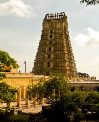
In 1827 ad, krishnaraja wodeyar iII repaired The Shrine and built the present beautiful seven-tiered gopura at the entrance, with seven golden kalashas atop it.
The Temple holds deep Shakti Peetha significance, it is believed That The Hair Of Mata Sati Fell at this very spot, Making it One Of The 18 Maha Shakti Peethas, known as Krouncha Pitham
How To Reach
By bus : ksrtc operates regular bus services every day from mysore city bus stand to The Temple. There is also a motorable road from the rear nanjangud side.
By train : the nearest railway station is mysore railway station, about 6 km from The Temple.
By air : the nearest airport is mysore airport, approximately 15 km away, connected with domestic flights. Holidify from the airport, hire a taxi or auto-rickshaw to The Temple.